


Geofence or Ghetto? Is This the Inevitable Evolution of Location-Based Services?
Virtual zones created over physical areas can serve a beneficial purpose for society. But are the unintended consequences worth the risk?

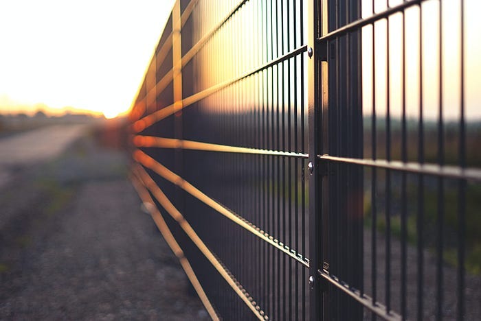
I recently moved to Austin, TX, where scooters are one of the primary modes of transportation. It doesn’t matter where you are in the city, you’ll likely cross paths with someone zipping by on one.
A few weeks ago, I picked up a scooter to take a ride along South Congress, one of the main thoroughfares in the city. As I got on the bridge to cross the river, my scooter came to an abrupt halt.
Scooters aren’t new to me. I had ridden them in DC when they first started appearing on sidewalks in late 2017/early 2018. I knew scooters could be programmed to operate at a lower speed — as was the case in DC — but stopping? That was news to me.
Eventually, I learned that in Austin, motorized scooters are prohibited on the Hike and Bike Trail that lines the north and south sides of Lady Bird Lake. To enforce this rule, scooters operated by providers like Lime have been programmed to stop working when they’re in a prohibited geographic area.
That explained why my scooter suddenly stopped. It wasn’t a mechanical issue with the scooter — something I was worried about — it was where I was located. Even though I wasn’t on the trail, I was still crossing over it. Once I manually scooted myself away from the trail zone, the scooter started working again as it was supposed to.
This is an example of how advances in technology enable movement restrictions for an otherwise venerable cause. The Trail Conservancy, a local environmental nonprofit, noticed that scooters were being dumped into Lady Bird Lake, polluting the waterway. The group took action. The outcome: prohibiting the use of motorized micromobility methods on the trail.
This effort seems rather benign on the surface. It helped save the environment after all. But what happens when the same technology that’s used to restrict the movement of Lime scooters on a public trail is applied to all forms of movement?
This essay is going to dive into that question. It’s going to evaluate the unintended consequences of omni-use technologies by looking at the implications of how geofencing — the patent-pending technology Lime uses to prohibit the use of its scooters in restricted areas — can be leveraged to restrict the freedom of movement writ large.
While there might be good reasons for limiting movement, it doesn’t stop with the conservation of waterways and trails. We have to be prepared for wider applications of this technology too.
Cities began testing geofencing in 2018. It creates zones and uses GPS data to disable a scooter if it’s in a restricted area.
According to Lime, one of the main scooter operators in Austin, the idea of geofencing is to:
Use GPS [to] create geofenced areas, or ‘zones’ that allow us to create specific rules based on the location of the scooter, from designating parking areas to reducing the maximum speed limit on busy corridors.
Zone maps are housed directly on the scooters instead of a distant server or somewhere in the cloud. With Lime, that means:
The scooter will be able to tell if it’s within a zone perimeter as frequently as every 1 second.
When you think about it, geofencing makes sense. It’s a way for a company like Lime to mitigate risk, protect users from taking rides in areas they shouldn’t, and helps build confidence with municipalities by reducing the nuisance scooters often create for the general public.
While the idea of geofencing creates some benefits for micromobility platforms like scooters, the technology itself isn’t restricted to scooter use. With geofencing, it’s now possible for cities to create zones to monitor — and limit — activities in those zones.
Take law enforcement as an example. It’s well known that sex offenders are prohibited from going near places where children could be present, like schools, playgrounds, movie theaters, and libraries. If you didn’t already know this, there’s a national registry where you can look up the names and addresses of sex offenders to see where they live in your community.
Enforcing the movement of sex offenders is difficult. Oftentimes, it works on an honor system. Either the offender discloses to police that they’ve gone near a place with children, or they wait for someone from the neighborhood watch to do it for them.
Rules are in place to deter movement, but they don’t actually restrict it. Just short of the fear of being sent to jail, nothing realistically stops a sex offender from walking into a school.
Geofencing could change that.
Whether it’s your phone, a smartwatch, or the internet connection in your car, geofencing makes it possible to create zones that monitor and limit the operations of certain individuals. When the GPS data of a registered sex offender shows they’re in a zone they shouldn’t be in, an alert could be sent to law enforcement immediately. Now, instead of hoping they don’t go near children, geofencing could make it increasingly impossible for them to do so.
That is just one example of how this technology could be deployed, but there are other seemingly benevolent ways to leverage it too. Municipalities can use geofencing to create smart grids on busy streets to make it easier for parking enforcement to ticket violators. Instead of asking you to slow down in a work zone, a geofence could slow your car down for you. And for teenagers learning how to drive, geofences, in combination with other technology, can be used to limit their time behind the wheel and restrict their movements at specific times of day.
When used properly, geofencing can make roads safer and allow law enforcement to do their job more efficiently. It has the real potential to save lives and taxpayer dollars.
But with every new technology, there are downsides. While American companies like Lime are jumping at the prospect of utilizing geofencing to make their businesses more compliant with the whims of locals, other countries are using complementary technologies to limit the movement of their citizens. Combined, this could spell disaster for the future of the freedom of movement.
In 2014, China unveiled its social credit system. It shows how geofencing can be deployed to restrict the movement of anybody — not just electric scooters.
For geofencing to work, it needs data. It needs to be programmed with rules and protocols to follow. What if you extend that beyond GPS coordinates?
A precursor to what this could look like is already happening in China. Back in 2014, China rolled out a social credit scoring system as a way to verify trust. Whether you’re engaging in a business partnership or buying groceries at the supermarket, it’s intended to be a way to quantify how trustworthy a person is.
When you think about it, this isn’t all that different from a FICO score — or credit score — here in the United States. That score is primarily used to evaluate your trustworthiness as a borrower. Over the years, the role of FICO scores has started to grow. It’s not uncommon for an employer to check your credit before extending a formal offer of employment, and people have even started posting their score to their dating profiles to signal to a potential mate that they are a responsible adult.
While the idea of scoring people might seem good, that isn’t always the case. A few years after unveiling its social credit score, China announced it would begin barring people with low credit from certain modes of transportation. These aren’t criminals who have been prosecuted for a crime in a court of law. These are people who have committed “misdeeds,” a loosely defined term that could range from spreading misinformation to getting one too many parking tickets. These people are flagged in a national database, prohibiting them from taking certain forms of transportation, like high-speed trains and domestic flights.
The obvious problem with this is that it requires an enforcement mechanism. If the government isn’t surveilling you to make sure you behave properly, rest assured your neighbor is.
Without a geofence, the implementation of travel restrictions is limited. You have to maintain a database that regularly updates a list of names based on an individual’s score. Similar to America’s No Fly List, when your ID is scanned at an airport or train station, you’ll be denied a ticket if your name is on such a list.
But what happens when you digitize the implementation of this by programming a geofence based on individual scores, not just GPS coordinates? Your score would act as a passport in some ways. Zones could be created based on certain scores and you would be admitted or denied entrance into that zone based on your personal score. Thanks to the ubiquity of GPS-enabled devices, something like this wouldn’t be too difficult to implement. Simply alert the local authorities standing by that someone has entered a restricted area and use facial recognition to detain the trespasser.
If you’re reading this and envisioning the de facto digital ghettoization of cities based on a scoring system — like a social credit score or a financial credit score — you’re not far off. We already segregate ourselves socioeconomically; a geofence would just make it easier.
But geofencing could go beyond even that. Imagine if a state that criminalizes access to certain healthcare procedures — like having an abortion — creates a geofence to protect its borders. Let’s say it justifies this on the basis of security. There’s an influx of illegal immigrants streaming across its southern border, after all. A geofence would go a long way to help law enforcement secure the border.
It doesn’t matter whether the geofence is used for immigrants or not, the technology exists. And without guardrails in place, there’s nothing stopping the state from using it to monitor illegal abortions too. Simply connect it to a database — like vehicle registrations through the DMV — and now you can monitor the movement of all women of child-bearing age into and out of the state.
On the surface, geofencing may seem like a valuable technology. It makes roads safer and protects the environment. But when combined with a numerical score and tied to a personal record, a geofence can be used for far more than safety. It raises an important question about how geofencing could be used to limit movement in the not-so-distant future.
Final takeaway.
Unfortunately, the future is already here.
Fortuitously, as I began drafting this essay, a connection on LinkedIn shared the following post to my feed:
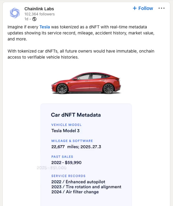
Tokenization of data with internet-connected devices — like Teslas — is already here. Combine that with pushes by organizations like Worldcoin and Amazon to create biometric verification and payment systems and it’s not a far stretch to argue that vehicles could soon be programmed to operate based on specific criteria: the number of unpaid tickets you have, your driving history, how much you still owe on your vehicle, or a even a social credit score.
Tokenization of data to create a digital identity is the logical step for new technologies that are coming online. It makes sense to house critical information all in one place: your driver’s license, credit score, and blood type are just a few data points worth mentioning. Your phone — a GPS-enabled device — would be the primary vehicle to carry a digital ID around with you wherever you go. What is stopping someone from setting up a geofence that uses data housed in a digital ID to restrict your movement or worse — limit your commercial activities?
The emphasis on mobility is important and it’s why I specifically chose to highlight it in this essay to illustrate my point. Throughout history, transportation has been a harbinger of civilization’s success. The ones who survived and thrived were the ones who had unfettered access to waterways that facilitated commerce. The freedom to travel wherever we please is a fundamental right that is directly correlated to economic prosperity. Yet most of us in the United States are completely unaware of it and take it for granted.
A nonprofit, a city government, and a micromobility company created a system here in Austin to restrict movement on a public trail. But what happens when the same technology — combined with key personal data points — is applied more broadly? How could geofencing be used to limit mobility and, thus, economic activity?
These are questions we need to start asking ourselves. What are we going to do to make sure none of what I just laid out in this essay ever happens?